Based on the NOAA’s historical tropical storm tracks data, which includes storms dating as far back as 1850, the map above shows a top-down view of every hurricane, cyclone, and typhoon in recorded hi — Map created by Vividmaps in CartoDB
Get Started for FREE
Sign up with Facebook Sign up with X
I don't have a Facebook or a X account


 Your new post is loading...
 Your new post is loading...
Your new post is loading...
Based on the NOAA’s historical tropical storm tracks data, which includes storms dating as far back as 1850, the map above shows a top-down view of every hurricane, cyclone, and typhoon in recorded hi — Map created by Vividmaps in CartoDB
Tony Hall's insight:
This a brilliant map! I love the pattern created by the storm tracks. Especially the empty space around the equator.

No comment yet.
Sign up to comment
The disastrous earthquake in Haiti taught humanitarian groups an unexpected lesson: the power of mobile devices to coordinate, inform, and guide relief efforts.
Tags: technology, disasters, Haiti, TED.
Tony Hall's insight:
This is why ICT is important. No. Vital! Our students need to see things like this so that they understand the positive aspects of technology. They need to see that SMS, Facebook & Twitter are so much more than just a way sharing silly photos of themselves. This technology has the power to affect real, positive change.

techsavvygirl's curator insight,
February 18, 2013 8:21 AM
Augmenting human potential with smartphones 
GTANSW & ACT's curator insight,
April 23, 2016 4:11 AM
Responding to disasters and preparedness using technology
|
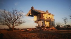
The first anniversary of Superstorm Sandy's landfall in New Jersey. Sandy was the largest Atlantic hurricane on record (by diameter), the second-costliest storm in U.S. history, affecting 24 states...
Tony Hall's insight:
An interesting set of images. Useful for discussion the impact of hurricanes on the cultural environment.
|